

When it comes to utility markings nationwide, specific color codes are used. These color codes are used to indicate the type of utility that is present, such as gas, water, or electricity. It is essential to follow these color codes when marking utility locates, as it helps prevent accidents and ensures that work can be done safely and efficiently. Understanding these color codes is crucial for any construction or digging project.

Image Source: GPRA
Utility markings with these colors are everywhere, especially around new construction. What do these flags and spray-painted markings mean? Why do we use them?
Once Upon a Time in the Wild West
In 1976, construction workers accidentally cut into a petroleum pipeline that ran under the streets of Culver City, California, resulting in a fatal explosion that essentially leveled half of a city block. It wasn’t the first or last accident of this kind, sparking efforts to catalyze the systemization of critical color-coded utility markings — mysterious-looking tags look like nonsense or a secret code until you can decipher them.
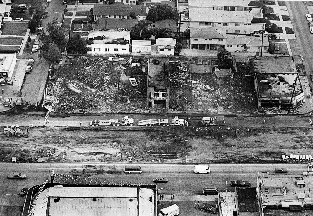
June 17, 1976: Air view of north side of Venice Blvd. where gasoline explosion destroyed seven buildings and killed four people. This photo was published in the June 18, 1976 Los Angeles Times. Photo taken from KMPC helicopter.
Aftermath of Explosion
On that fateful June 15th, workers began excavating Venice Boulevard to widen the road when disaster struck. Pressurized gas from a ruptured line ignited a fireball and caused smoke to rise hundreds of feet into the air. Flames engulfed businesses and apartment buildings along the block, killing and injuring dozens of people.
Three months later, the state created the DigAlert system for contractors and citizens to contact when planning a subterranean dig to help avoid future disasters. While DigAlert may have been the first, numerous organizations have since been formed to track underground utilities.
Proper Practices For Utility Markings
Appropriate colors should be used to mark utilities when possible. Each state’s 811 One Call hotline system has implemented specific color codes for labeling all utility locates nationwide.
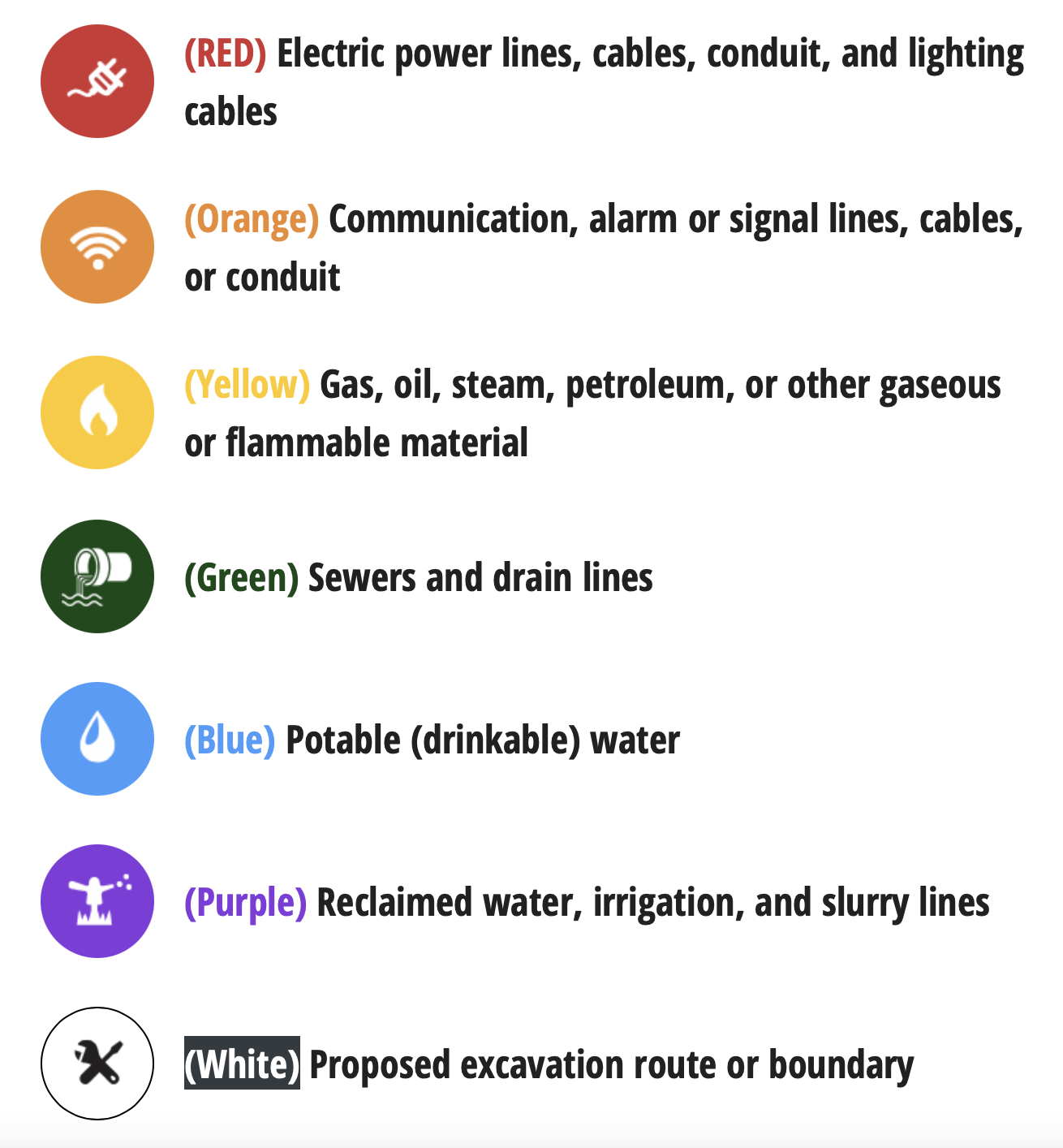
Image Source: va811.com
These colors help identify unseen hazards that need to be considered during excavation, but the color system only warns construction workers of the type of hazard. Once the uniform color code went into place, other utility marking codes followed to appropriately identify underground conduits, cables, pipes, their facility owners, and descriptions of the facility.
Express-Tek‘s field crews survey and document these lines to create a base map. These are then used to design a cable/conduit path for our client’s needs.
For example, according to the guidelines, spray-painted lines for marking a single facility can be done in two ways. The first is to place lines marking the center of the facility, as seen in the image below.
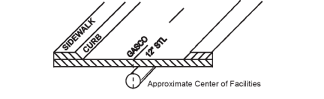
Image Source: CGA
The second is to mark the outside edges of the facility with a horizontal line drawn through the center to form an H-shape.
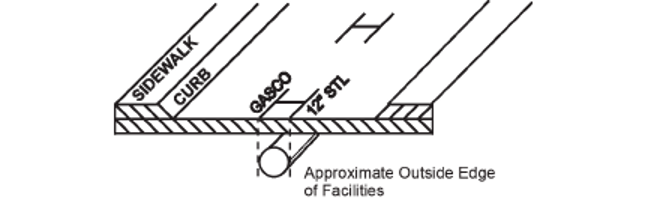
Image Source: CGA
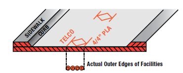
Another common symbol is the diamond shape used to mark a conduit. Here you can see four 4-inch plastic conduits and the telecommunications company owner.
When there is “no conflict” between buried utilities and the proposed area of excavation, locators will mark “NO” oftentimes followed by the name of the facility, or the abbreviated facility type with a line drawn through it. The image below shows both: “G” for gas with a line slashed through it—indicating no conflict with gas facilities.
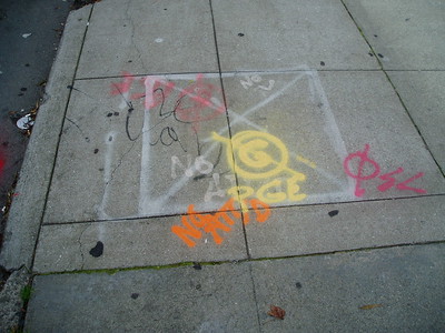
Image Source: Friends of the Urban Forest on Flickr.
Express-Tek uses these markings and other materials to prepare schematics and permittable packages for our clients.
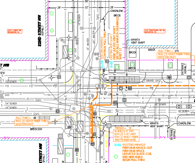
Sample CAD drawing used by Express-Tek with color-coded utility markings.
Almost all jurisdictions (City, county, state, etc.) require minimum clearance from existing utilities. These need to be determined, depicted, and the proper design shown before releasing a permit for construction. Express-Tek will use available information such as, but not limited to, utility schematics, GIS sites, As-Builts, and the site walks to determine what lies beneath.
Mapping and marking the underground infrastructure is a complex task, and these symbols provide a brief window into these intricate systems. Next time you run into cryptic street scribbles, you’ll know these annotations are critical for damage prevention and public safety.
Article written by Mark Meyers, Sr. Project Manager | Chesapeake, VA | [email protected]